Introduction
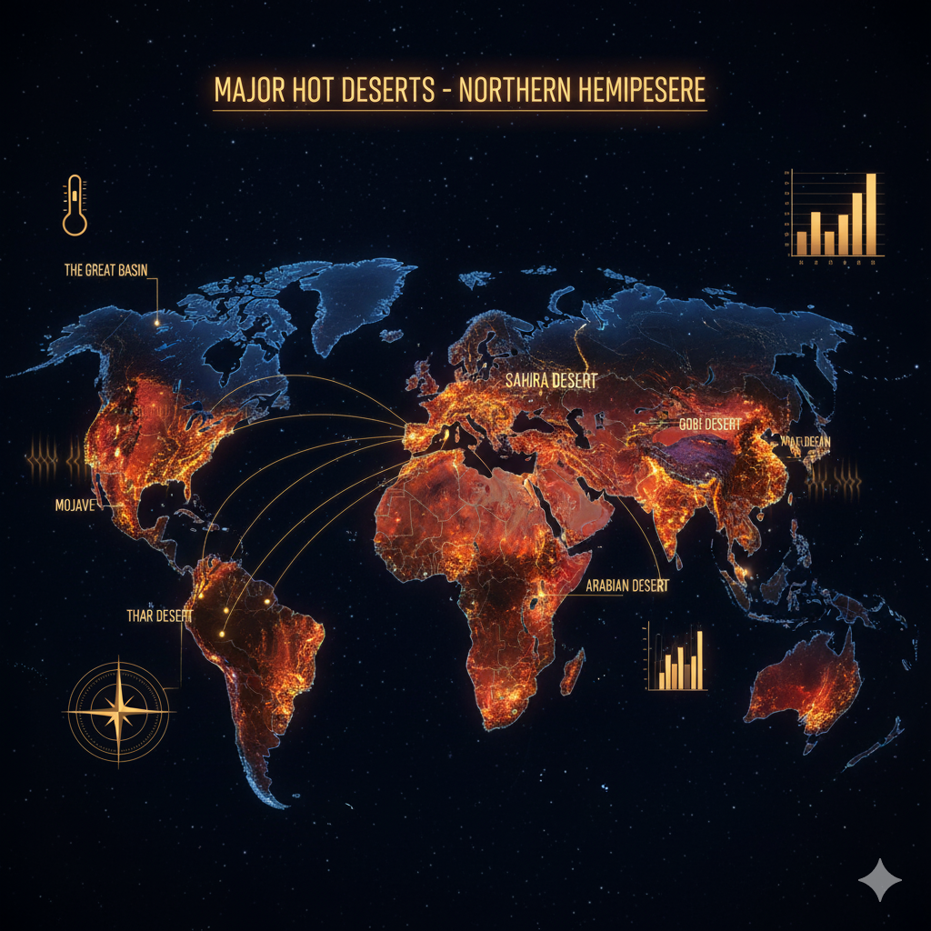
Deserts are among the most striking and unique landscapes on Earth. They represent regions of extreme aridity, where annual rainfall is minimal, and evaporation exceeds precipitation by a large margin. Interestingly, a striking pattern emerges when one observes the global distribution of deserts — most of the major hot deserts in the world are concentrated between 20° and 30° latitudes north and south of the equator, and particularly, in the western margins of continents.
In the Northern Hemisphere, this pattern is distinctly visible with the presence of prominent deserts such as the Sahara Desert in Africa, the Arabian Desert in the Middle East, the Thar Desert in India and Pakistan, the Mojave and Sonoran Deserts in North America, and the Mexican Desert Plateau. These deserts occupy similar latitudinal zones and share comparable climatic and geographical characteristics.
The underlying causes for this specific distribution are rooted in global atmospheric circulation patterns, ocean currents, continentality, and mountain barriers, which together create the dry, hot conditions that define these arid environments. This essay critically explains why most of the major hot deserts in the Northern Hemisphere are located between 20°–30° N latitudes and on the western sides of continents, by examining the interplay of meteorological, geographical, and oceanic factors.
1. Global Distribution Pattern of Hot Deserts
When plotted on a world map, it becomes evident that most hot deserts cluster within the subtropical high-pressure belt, extending roughly between 20° and 30° latitude in both hemispheres.
Examples from the Northern Hemisphere include:
- Sahara Desert – North Africa
- Arabian Desert – Arabian Peninsula
- Thar Desert – India and Pakistan
- Mojave, Sonoran, and Chihuahua Deserts – North America
- Iranian Plateau Desert – Central Asia
All these deserts share certain environmental and climatic similarities, including low annual precipitation (less than 250 mm), high diurnal temperature range, intense solar radiation, and sparse vegetation cover. Their concentration along the western edges of continents is not coincidental; rather, it is a result of atmospheric circulation and oceanic influences.
2. Role of Global Atmospheric Circulation: The Subtropical High-Pressure Belt
The fundamental reason for the latitudinal distribution of hot deserts lies in the Hadley Cell circulation, a key component of Earth’s general atmospheric system.
2.1 The Hadley Cell Mechanism
Warm air rises near the equator due to intense solar heating, forming the Intertropical Convergence Zone (ITCZ) where convectional rainfall is abundant. This rising air, after releasing moisture as rain, moves poleward in the upper troposphere. Around 20° to 30° latitude, the air cools and descends, forming a zone of high pressure known as the subtropical high-pressure belt or horse latitudes.
This descending air is dry and warm, as it has already lost its moisture during its ascent near the equator. When it sinks, it undergoes adiabatic heating — the process where air warms due to compression — thereby inhibiting cloud formation and rainfall.
2.2 Formation of Arid Conditions
This descending dry air mass creates stable atmospheric conditions, leading to clear skies, intense sunshine, and low humidity, all of which are conducive to desert formation. Thus, the subtropical high-pressure zones mark the global belts of aridity.
Therefore, most hot deserts, including the Sahara, Arabian, and Thar, exist under this descending limb of the Hadley Cell, explaining their consistent placement between 20°–30° latitudes.
3. The Role of Ocean Currents: Cold Currents on Western Margins
One of the most critical factors explaining why deserts are typically found on the western sides of continents is the presence of cold ocean currents flowing along these coasts.
3.1 Influence of Cold Ocean Currents
Cold currents, such as the Canary Current (Atlantic Ocean), California Current (Pacific Ocean), and Benguela Current (off the coast of Africa), lower the temperature of the air above them. When the cool, stable air moves over the adjacent land, it suppresses convection — preventing the air from rising and forming rain clouds.
The result is a dry, stable atmosphere along the western coastal regions, reinforcing aridity.
3.2 The Process of Fog and Dew Formation
While these cold currents inhibit rainfall, they may cause fog and dew along the coastlines due to condensation of moisture near the surface. This explains phenomena like the fog deserts (e.g., the Namib Desert in Southern Hemisphere) and the coastal fog zones along the western Sahara.
However, these moisture forms rarely result in significant rainfall, keeping the overall climate extremely dry.
3.3 Example: Sahara and Arabian Deserts
The Sahara Desert’s western edge is influenced by the cool Canary Current in the Atlantic Ocean, while the Arabian Desert’s southwestern coast experiences the effects of the cold Red Sea and Persian Gulf currents, both of which reduce precipitation levels. Similarly, the Mojave and Sonoran Deserts in North America lie adjacent to the California Current, reinforcing the dry, warm climate.
4. Continentality and Rain Shadow Effects
Another key factor responsible for desert formation is continentality—the influence of a location’s distance from oceanic moisture sources—and mountain-induced rain shadows.
4.1 Continental Interiors
Regions situated deep within continents, far from moisture-bearing winds, tend to be dry because the air loses much of its moisture before reaching these interiors. For instance, the Arabian Desert and Iranian Plateau are largely continental deserts where moist air from the Indian Ocean rarely penetrates due to long distances and mountain barriers.
4.2 Rain Shadow Effect
When moist winds encounter mountain ranges, they are forced to ascend. The rising air cools and releases moisture on the windward side, leaving the leeward side dry.
This orographic effect creates rain shadow deserts, such as the Thar Desert, which lies on the leeward side of the Aravalli Range. Similarly, in North America, the Great Basin and Mojave Deserts exist due to the rain shadow created by the Sierra Nevada Mountains blocking Pacific moisture.
Thus, both continentality and orographic barriers contribute significantly to the dryness of deserts located around 20°–30° N latitudes.
5. High Solar Insolation and Atmospheric Stability
The subtropical zones experience intense solar radiation due to the near-perpendicular incidence of sun rays for much of the year. This leads to high ground temperatures during the day, while clear skies allow rapid cooling at night, creating a large diurnal temperature range.
5.1 Stable Atmospheric Conditions
The descending air of the subtropical high-pressure belt creates stable stratification in the atmosphere. The warm air near the surface cannot rise, thus preventing cloud formation and rainfall. The clear sky also enhances radiative heating, making daytime temperatures soar.
5.2 Resulting Climate Characteristics
- Very high daytime temperatures (often exceeding 45°C)
- Very low humidity levels
- Intense solar radiation with minimal cloud cover
- Cold nights due to rapid radiation loss
These climatic features make the 20°–30° N belt ideal for hot desert formation.
6. Global Trade Winds and Dry Air Advection
Trade winds also play a critical role in maintaining desert conditions. Between the equator and 30° N, the northeast trade winds blow from the subtropical high-pressure zones toward the equatorial low-pressure zone.
These winds are dry as they originate from the descending air of the subtropical highs. When they move across the continental interiors, they desiccate the landscape further by increasing evaporation rates.
Thus, regions such as the Sahara, Arabian Peninsula, and northwestern India are constantly under the influence of these dry, subsiding air masses, sustaining their arid conditions throughout the year.
7. Case Studies of Major Hot Deserts in the Northern Hemisphere
7.1 The Sahara Desert
The Sahara Desert, the world’s largest hot desert, covers about 9 million square kilometers across North Africa. It lies roughly between 15° and 30° N latitudes, extending across countries like Egypt, Libya, Algeria, Morocco, and Sudan.
Its location under the subtropical high-pressure belt, combined with the Canary Current along its western coast, ensures extremely dry conditions. The Atlas Mountains to the north further block moisture-bearing winds from the Mediterranean, creating a vast arid expanse.
7.2 The Arabian Desert
Located on the Arabian Peninsula, this desert extends from the Red Sea to the Persian Gulf. It lies entirely within the descending limb of the Hadley Cell, receiving minimal rainfall.
The surrounding Taurus and Zagros Mountains restrict moisture inflow, while the high-pressure zones above the peninsula create persistently hot, dry air masses.
7.3 The Thar Desert
The Thar Desert, located in northwestern India and southeastern Pakistan, owes its aridity to both continental and monsoonal factors.
It lies in the rain shadow region of the Aravalli Range, receiving little rainfall from the southwest monsoon. Additionally, the continentality and subtropical high-pressure influence accentuate dryness.
This desert also marks the easternmost extension of the subtropical desert belt.
7.4 North American Deserts
The Mojave, Sonoran, and Chihuahuan Deserts occupy the southwestern United States and northern Mexico, between 25° and 35° N.
Their formation is closely linked to the cold California Current and the rain shadow of the Sierra Nevada Mountains. These combined effects produce one of the driest regions in North America.
7.5 The Iranian and Turkestan Deserts
The Iranian Plateau, including the Dasht-e Kavir and Dasht-e Lut, lies in the interior of Southwest Asia. These deserts are far from any moisture source, surrounded by high mountains that block rain-bearing winds. Their continental location and high-pressure dominance contribute to their extreme aridity.
8. Interplay of All Causal Factors
The formation of deserts between 20°–30° N latitudes is not due to a single factor but a synergistic interaction of multiple environmental processes:
- Hadley Cell subsidence creates dry, stable air.
- Cold ocean currents cool coastal regions, suppressing rainfall.
- Mountain barriers block moisture-laden winds.
- Continental interiors remain far from maritime influences.
- Strong solar radiation intensifies ground heating.
Together, these processes create a persistent belt of aridity that aligns remarkably with the desert distribution across the Northern Hemisphere.
9. Broader Climatic and Ecological Implications
9.1 Climatic Extremes
The hot deserts exhibit some of the most extreme climatic conditions on Earth, including record high temperatures such as 58°C in Libya’s Sahara and 56°C in Death Valley (USA). These regions also experience large diurnal and seasonal temperature variations due to low humidity and clear skies.
9.2 Ecological Adaptations
Despite harsh conditions, desert ecosystems host highly specialized flora and fauna. Plants like cacti, acacias, and succulents have evolved water conservation mechanisms, while animals such as camels, fennec foxes, and desert reptiles display physiological and behavioral adaptations to heat and scarcity of water.
9.3 Human Settlements and Challenges
Human habitation in deserts is sparse but not absent. Nomadic pastoralism, oasis agriculture, and mineral exploitation are common livelihood activities. However, increasing desertification, water scarcity, and climate change threaten the delicate ecological balance of these arid regions.
10. Conclusion
The concentration of major hot deserts between 20°–30° N latitudes and on the western margins of continents is a result of planetary-scale atmospheric and oceanic dynamics rather than coincidence.
The descending limbs of the Hadley Cells, the presence of cold ocean currents, continental interiors, and mountain rain shadows collectively create the arid environments characteristic of this zone.
These processes have operated over geological timescales to shape the Earth’s most iconic drylands — from the vast expanse of the Sahara to the rugged terrain of the Mojave and Thar Deserts. Understanding these underlying mechanisms is essential not only for the study of physical geography and climatology but also for developing sustainable strategies to manage human and ecological life in these fragile ecosystems.
Thus, deserts are not merely barren wastelands; they are complex climatic expressions of the Earth’s atmospheric equilibrium, intricately linked with global wind systems, ocean currents, and the planet’s thermal balance.