Introduction
Tropical cyclones are among the most powerful meteorological phenomena on Earth. Known by different names in different regions—hurricanes in the Atlantic and Gulf of Mexico, typhoons in the western Pacific and South China Sea, and cyclones in the Indian Ocean—they are characterized by intense low-pressure systems with spiraling winds, heavy rainfall, and destructive storm surges.
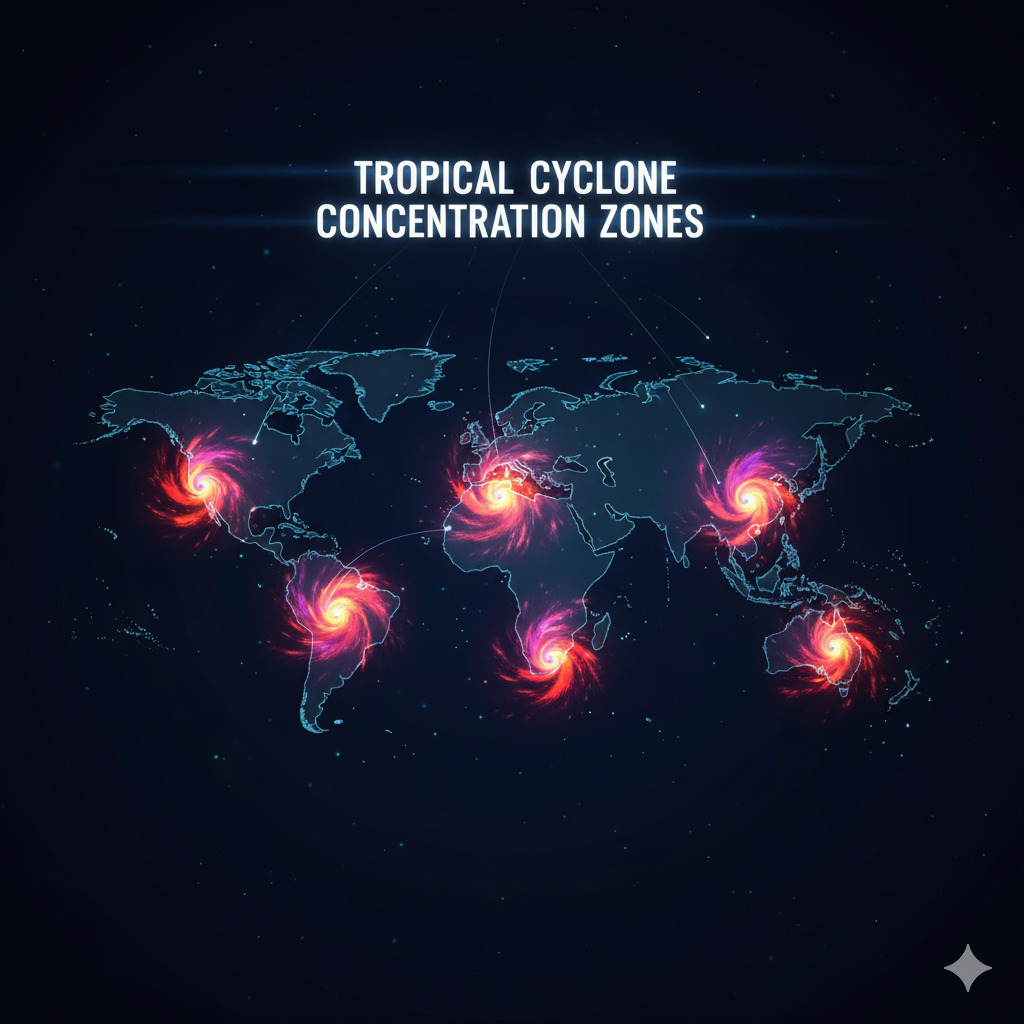
Interestingly, tropical cyclones are not evenly distributed across the globe. Instead, they are largely confined to a few major basins, with the South China Sea, the Bay of Bengal, and the Gulf of Mexico emerging as critical hotspots. This pattern raises a fundamental geographical question: why are these regions so prone to tropical cyclones, while others, even with warm seas, witness far fewer storms?
To answer this, we need to critically examine the factors responsible for cyclone formation, the geographical peculiarities of these regions, and the atmospheric-oceanic dynamics that make them ideal breeding grounds for tropical cyclones.
Conditions Necessary for the Formation of Tropical Cyclones
For a tropical cyclone to form, certain physical and atmospheric conditions must coexist:
- Sea Surface Temperature (SST) above 26.5°C: Warm oceans provide the latent heat of condensation, which fuels cyclone development.
- Coriolis Force: A sufficient distance from the equator (generally >5° latitude) is necessary to allow the Coriolis effect to initiate cyclonic rotation.
- High Humidity in the Troposphere: Particularly in the middle layers, to sustain convection.
- Pre-existing Disturbance: Such as low-pressure troughs or tropical waves to kickstart circulation.
- Weak Vertical Wind Shear: Strong wind shear disrupts vertical alignment of the cyclone system, preventing intensification.
- Upper Atmospheric Outflow: Efficient removal of air from the top of the system enhances upward motion at the center.
These universal requirements explain why only certain basins of the world are cyclone-prone, particularly the South China Sea, Bay of Bengal, and Gulf of Mexico, which consistently meet these conditions.
Tropical Cyclones in the South China Sea
Geographical Setting
The South China Sea is a semi-enclosed marginal sea of the western Pacific Ocean, bordered by Southeast Asian nations and influenced heavily by the Pacific monsoon system.
Reasons for High Cyclone Activity
- Warm Sea Surface Temperatures (SST): The western Pacific, including the South China Sea, is the warmest oceanic region in the world, often called the “warm pool.” This provides immense energy for cyclone formation.
- Frequent Monsoonal Disturbances: Tropical depressions originating in the Pacific move westward and intensify in the South China Sea.
- High Ocean Heat Content: Not just surface warmth, but deep warm waters allow cyclones to maintain intensity.
- Converging Trade Winds: The interaction of northeast and southwest monsoons increases low-pressure conditions.
- Low Vertical Wind Shear: Favors cyclone intensification.
- Geographical Funnel Effect: The semi-enclosed nature of the South China Sea intensifies storm surges and damage potential.
Cyclone Characteristics
- Known as typhoons, these storms often attain super-typhoon strength.
- Countries like the Philippines, Vietnam, China, and Taiwan frequently face devastating landfalls.
- Example: Typhoon Haiyan (2013), one of the strongest tropical cyclones ever recorded, caused catastrophic destruction in the Philippines.
Tropical Cyclones in the Bay of Bengal
Geographical Setting
The Bay of Bengal, located in the northeastern Indian Ocean, is surrounded by India, Bangladesh, Myanmar, and Sri Lanka. It accounts for some of the deadliest cyclones in recorded history.
Reasons for High Cyclone Activity
- Warm Ocean Temperatures: The bay consistently records SST above 28°C, ideal for cyclone formation.
- High Humidity from Monsoons: The southwest monsoon supplies huge amounts of moisture, fueling cyclonic systems.
- Geographical Shape: The funnel-shaped bay amplifies storm surges, making cyclones particularly deadly.
- Shallow Depths: Shallow waters quickly heat up, providing abundant latent heat.
- Intertropical Convergence Zone (ITCZ): The seasonal migration of ITCZ across the Bay facilitates low-pressure systems.
- Low Wind Shear in Pre-Monsoon and Post-Monsoon Seasons: Encourages cyclogenesis during April–June and October–December.
- Influence of Madden-Julian Oscillation (MJO): Enhances convective activity, triggering cyclonic disturbances.
Cyclone Characteristics
- Known as cyclones in this region.
- Highly destructive due to dense coastal population and poor disaster preparedness historically.
- Examples:
- Cyclone Bhola (1970): Deadliest tropical cyclone, killed over 300,000 in Bangladesh.
- Cyclone Amphan (2020): A super-cyclone that devastated eastern India and Bangladesh.
Tropical Cyclones in the Gulf of Mexico
Geographical Setting
The Gulf of Mexico, a marginal sea of the Atlantic Ocean, lies adjacent to the southeastern United States, Mexico, and Cuba.
Reasons for High Cyclone Activity
- High SSTs During Summer: The Gulf often records surface temperatures exceeding 30°C.
- Enclosed Basin Effect: Its semi-enclosed nature traps warm waters, providing continuous energy to cyclones.
- Proximity to the ITCZ and Atlantic Trade Winds: These supply initial disturbances that evolve into tropical storms.
- Warm Loop Current: A deep warm ocean current in the Gulf sustains cyclone intensification.
- Low Wind Shear During Peak Season (August–October): Allows storms to strengthen into hurricanes.
- Moist Maritime Air Masses: High humidity levels aid in vigorous convection.
Cyclone Characteristics
- Known as hurricanes in this region.
- The U.S. Gulf Coast, Mexico, and Caribbean islands are highly vulnerable.
- Examples:
- Hurricane Katrina (2005): One of the deadliest U.S. hurricanes, causing over 1,800 deaths.
- Hurricane Harvey (2017): Brought record-breaking rainfall and flooding in Texas.
Why Not Other Regions?
- South Atlantic Ocean: Rare cyclones due to cool SST, strong vertical wind shear, and absence of pre-existing disturbances.
- Eastern South Pacific: Similar reasons—cool water from Humboldt Current and unfavorable atmospheric conditions.
- Polar Regions: Too cold for cyclogenesis.
- Mediterranean Sea: Small water body; cyclones are rare, though “medicanes” (Mediterranean hurricanes) occasionally form.
Thus, only select basins like the South China Sea, Bay of Bengal, and Gulf of Mexico provide the perfect balance of oceanic heat, atmospheric conditions, and geographical features.
Association with Climate Change and Future Trends
- Rising SSTs: Global warming increases the intensity (though not necessarily frequency) of tropical cyclones.
- Sea-Level Rise: Exacerbates storm surge impacts in vulnerable basins.
- Changing Wind Shear Patterns: Could alter cyclone tracks, making new areas vulnerable.
- Increased Rainfall: Cyclones are expected to carry more moisture, leading to extreme flooding.
The South China Sea, Bay of Bengal, and Gulf of Mexico will likely remain cyclone hotspots but with greater destructive potential in the coming decades.
Conclusion
Tropical cyclones are unevenly distributed across the globe because their formation depends on a delicate interplay of oceanic warmth, atmospheric stability, Coriolis force, and geographical settings. The South China Sea, Bay of Bengal, and Gulf of Mexico emerge as hotspots due to:
- Exceptionally warm waters,
- High humidity,
- Favorable wind conditions, and
- Semi-enclosed basin geography that intensifies cyclonic impacts.
While other parts of the world lack the right combination of these factors, these regions consistently provide the perfect conditions for cyclogenesis. Understanding these dynamics is crucial not only for geography and earth science studies but also for disaster preparedness in an era of climate change and rising coastal vulnerability.