Introduction
The Grand Canyon is one of the most remarkable fluvial landforms in the world and a classic example of the power of river erosion in shaping Earth’s surface. Located in the state of Arizona, United States, the Grand Canyon was carved primarily by the Colorado River and its tributaries over millions of years. Stretching approximately 446 kilometers (277 miles) in length, reaching widths of up to 29 kilometers (18 miles), and attaining depths of more than 1,800 meters (6,000 feet), it is one of the largest and most spectacular canyons on Earth.
The Grand Canyon is not merely a scenic natural wonder; it is also a valuable geological and geomorphological record of Earth’s history. Its exposed rock layers preserve nearly two billion years of geological evolution, making it one of the finest outdoor laboratories for studying sedimentation, tectonic activity, erosion, landscape evolution, and environmental change.
As a fluvial landform, the Grand Canyon demonstrates how a river, aided by weathering, mass wasting, and tectonic uplift, can transform a relatively flat plateau into an immense canyon. Understanding its formation provides important insights into geomorphic processes and the long-term evolution of continental landscapes.
What is a Fluvial Landform?
A fluvial landform is a landform created by the action of running water, particularly rivers and streams. Rivers shape the landscape through three major processes:
- Erosion – removal of rock and soil.
- Transportation – movement of sediments.
- Deposition – accumulation of sediments in new locations.
Examples of fluvial landforms include:
- Valleys
- Waterfalls
- Meanders
- Floodplains
- River terraces
- Deltas
- Canyons
- Gorges
The Grand Canyon is one of the world’s best examples of a canyon formed mainly by prolonged river erosion.
Location of the Grand Canyon
The Grand Canyon lies in northern Arizona within the Colorado Plateau.
Important Facts
- Country: United States
- State: Arizona
- River: Colorado River
- Length: About 446 km
- Maximum Width: About 29 km
- Maximum Depth: Over 1,800 m
Much of the canyon is protected within Grand Canyon National Park, a UNESCO World Heritage Site.
Geological Background
Before the canyon formed, the Colorado Plateau was a relatively elevated but mostly flat region composed of thick layers of sedimentary rocks.
These rocks were deposited over hundreds of millions of years in different environments, including:
- Ancient seas
- Rivers
- Deserts
- Coastal plains
- Swamps
The sedimentary sequence includes:
- Limestone
- Sandstone
- Shale
- Mudstone
Beneath these layers lie much older metamorphic and igneous rocks that are nearly 2 billion years old.
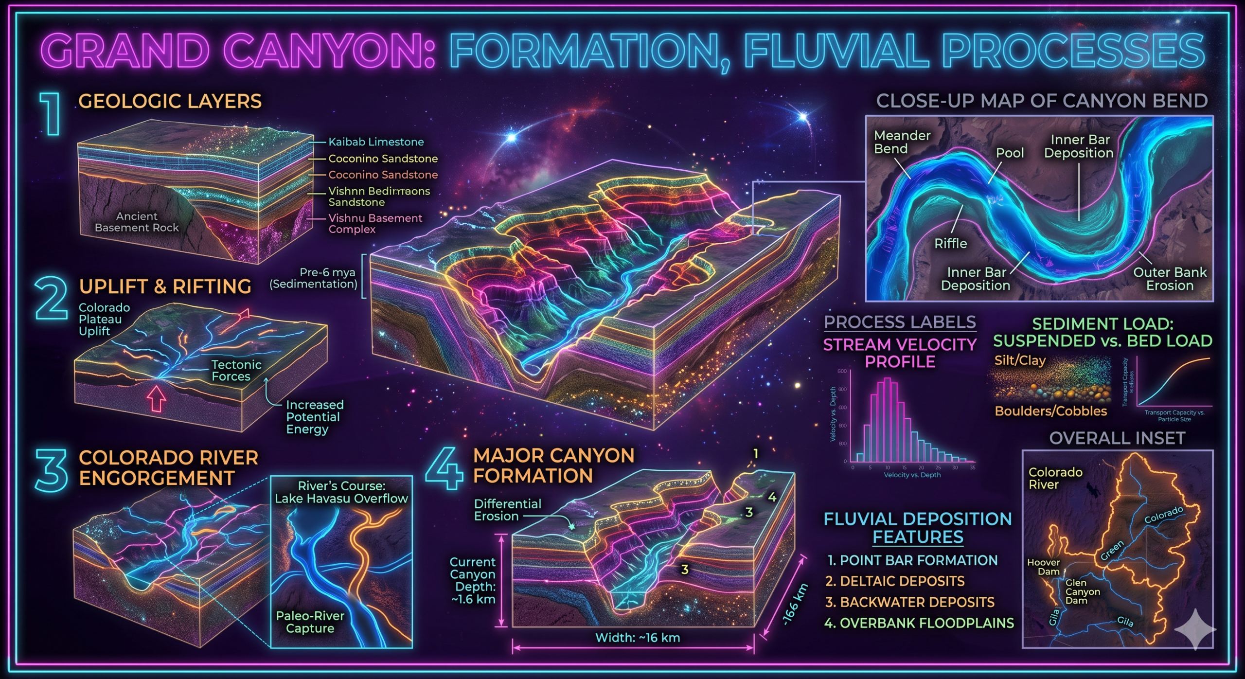
Formation of the Grand Canyon
The Grand Canyon developed through a combination of tectonic uplift, river erosion, weathering, and mass wasting. Its formation occurred gradually over millions of years rather than as a single event.
Stage 1: Deposition of Sedimentary Rocks
Between about 2 billion and 270 million years ago, different environments deposited thick layers of sediments across the Colorado Plateau.
These sediments eventually became rocks such as:
- Limestone
- Sandstone
- Shale
Each rock layer represents a different geological period and environmental condition.
Stage 2: Uplift of the Colorado Plateau
Around 70 to 30 million years ago, tectonic forces associated with the Laramide Orogeny uplifted the Colorado Plateau.
Unlike many mountain-building regions, the plateau rose largely without intense folding or faulting.
This uplift increased the elevation of the region and provided the steep gradient needed for river erosion.
Stage 3: Development of the Colorado River
Approximately 5–6 million years ago, the Colorado River became established across the uplifted plateau.
As the river flowed toward the Gulf of California, it began cutting downward into the elevated rocks.
The river’s increased energy enabled rapid vertical erosion.
Stage 4: River Downcutting
The Colorado River continuously eroded its channel through:
- Hydraulic action
- Abrasion
- Corrosion (limited)
- Sediment transport
The river carried rocks and sand that acted like natural cutting tools, deepening the canyon over millions of years.
Stage 5: Weathering and Slope Retreat
River erosion alone did not create the canyon’s enormous width.
Weathering weakened the canyon walls through:
Physical Weathering
- Freeze-thaw action
- Temperature changes
- Salt crystallization
Chemical Weathering
- Dissolution of limestone
- Oxidation
- Hydrolysis
Weathering loosened rocks, making them susceptible to collapse.
Stage 6: Mass Wasting
Gravity caused weakened rocks to move downslope.
Processes included:
- Rockfalls
- Landslides
- Debris flows
- Slumping
These processes widened the canyon while the river continued deepening its floor.
Ongoing Erosion
The Grand Canyon continues to evolve today.
The Colorado River still transports:
- Sand
- Gravel
- Silt
- Boulders
Rainfall, floods, and weathering continue modifying the canyon walls.
Although erosion is slower today than during earlier periods, landscape evolution remains active.
Fluvial Processes Responsible for Canyon Formation
The Grand Canyon owes its existence primarily to fluvial geomorphic processes.
1. Vertical Erosion
Vertical erosion deepened the river channel.
The uplifted plateau gave the Colorado River sufficient energy to cut downward rapidly.
2. Hydraulic Action
Fast-moving water forced itself into rock fractures.
Repeated pressure gradually broke apart the rocks.
3. Abrasion
Rock fragments carried by the river scraped the riverbed and canyon walls.
This acted like natural sandpaper, increasing erosion.
4. Transportation
The river transported sediments downstream.
Transport occurred through:
- Rolling
- Sliding
- Suspension
- Solution
Continuous sediment movement enhanced erosion.
5. Headward Erosion
The river system gradually extended upstream.
Tributaries enlarged the drainage network and increased erosion throughout the plateau.
Rock Layers of the Grand Canyon
One of the canyon’s greatest scientific values is its exceptionally well-preserved sequence of rock layers.
Major formations include:
- Kaibab Limestone
- Coconino Sandstone
- Hermit Shale
- Supai Group
- Redwall Limestone
- Muav Limestone
- Bright Angel Shale
- Tapeats Sandstone
- Vishnu Schist
These formations document changing environments over nearly two billion years.
Geomorphic Features of the Grand Canyon
The canyon contains numerous landforms created by fluvial and weathering processes.
River Gorge
The deepest part of the canyon is occupied by the Colorado River.
Cliffs
Hard rock layers form steep vertical cliffs.
Terraces
Different erosion rates create step-like surfaces along canyon walls.
Buttes
Isolated flat-topped hills remain after surrounding rocks erode.
Mesas
Broad, elevated flat-topped landforms occur along canyon margins.
Side Canyons
Tributary streams have carved hundreds of smaller canyons.
Talus Slopes
Rockfalls accumulate at the base of cliffs, forming talus deposits.
Geomorphological Significance of the Grand Canyon
The Grand Canyon is one of the world’s most important geomorphological features.
1. Classic Example of Fluvial Erosion
The canyon demonstrates how rivers can reshape landscapes through long-term erosion.
It provides one of the clearest examples of canyon development anywhere on Earth.
2. Evidence of Landscape Evolution
The canyon records millions of years of interaction among:
- Tectonic uplift
- River erosion
- Weathering
- Mass wasting
It illustrates how landscapes change gradually over geological time.
3. Geological Archive
The exposed rock layers preserve an extraordinary record of Earth’s history.
Scientists study:
- Ancient climates
- Marine environments
- Desert conditions
- Mountain-building events
- Evolution of life
Few places offer such a continuous geological record.
4. Understanding River Processes
The Grand Canyon helps geomorphologists understand:
- River incision
- Sediment transport
- Flood dynamics
- Drainage evolution
- Valley development
It serves as a natural laboratory for fluvial geomorphology.
5. Evidence of Tectonic Activity
The canyon demonstrates the influence of tectonic uplift on river erosion.
Without uplift of the Colorado Plateau, the Colorado River could not have carved such a deep canyon.
6. Educational Importance
The Grand Canyon is widely used for teaching:
- Physical geography
- Geology
- Geomorphology
- Earth science
- Environmental studies
Students can observe geological principles directly in the exposed rock formations.
7. Scientific Research
Researchers study:
- Erosion rates
- Rock formations
- Fossils
- Groundwater
- Climate history
- River hydrology
The canyon remains one of the world’s leading geological research sites.
8. Biodiversity
The canyon supports diverse ecosystems due to changes in elevation.
Habitats include:
- Desert vegetation
- Shrublands
- Pine forests
- Riparian ecosystems
Many rare plants and animals inhabit the region.
9. Tourism and Recreation
Millions of visitors explore the Grand Canyon every year.
Popular activities include:
- Hiking
- River rafting
- Camping
- Wildlife observation
- Photography
Tourism contributes significantly to Arizona’s economy.
10. Cultural and Historical Importance
The Grand Canyon has been home to Indigenous communities for thousands of years.
Several Native American tribes continue to maintain cultural and spiritual connections with the canyon.
The landscape also represents an important part of the natural heritage of the United States.
Environmental Challenges
Despite its protected status, the Grand Canyon faces several challenges.
These include:
- Climate change
- Water scarcity
- Reduced Colorado River flow
- Tourism pressure
- Air pollution
- Invasive species
- Wildfires
Careful management is essential to preserve its natural and scientific value.
Modern Techniques Used to Study the Grand Canyon
Scientists use advanced technologies to investigate the canyon.
These include:
- Satellite imagery
- Remote sensing
- Geographic Information Systems (GIS)
- LiDAR mapping
- GPS surveys
- Drone photography
- Radiometric dating
- Sediment analysis
These methods improve understanding of canyon evolution and ongoing geomorphic change.
Why the Grand Canyon is an Ideal Example of a Fluvial Landform
The Grand Canyon perfectly illustrates the work of rivers because:
- It was carved primarily by the Colorado River.
- River erosion remains active today.
- Weathering and gravity widened the canyon.
- The canyon exposes long-term landscape evolution.
- It demonstrates the interaction between tectonic uplift and river incision.
- It preserves outstanding examples of fluvial geomorphology.
For these reasons, it is regarded as one of the world’s finest natural examples of a fluvial landform.
Conclusion
The Grand Canyon is one of Earth’s greatest geomorphological wonders and an outstanding example of a fluvial landform. Its formation resulted from the combined effects of tectonic uplift, the erosive power of the Colorado River, weathering, and mass wasting acting over millions of years. The uplift of the Colorado Plateau provided the elevation needed for the river to cut deeply into ancient sedimentary rocks, while continuous erosion and slope retreat gradually widened the canyon into its present form.
Beyond its breathtaking scenery, the Grand Canyon is of immense scientific, educational, environmental, and cultural importance. It preserves nearly two billion years of geological history, offers valuable insights into river erosion and landscape evolution, supports diverse ecosystems, and serves as a world-renowned center for geological research and education. As one of the finest examples of fluvial geomorphology, the Grand Canyon continues to demonstrate the extraordinary ability of rivers to shape Earth’s surface over geological time and remains an enduring symbol of the dynamic processes that create and transform our planet’s landscapes.