Introduction
North America is the third-largest continent in the world, extending from the Arctic Ocean in the north to the tropical regions of southern Mexico and bordered by the Atlantic Ocean to the east and the Pacific Ocean to the west. The continent covers approximately 24.7 million square kilometers, accounting for about 16.5% of Earth’s total land area. Due to its vast size and complex geological history, North America exhibits an extraordinary variety of landforms, climates, ecosystems, and natural resources.
The physical landscape of North America has evolved over billions of years through tectonic activity, volcanic eruptions, mountain-building episodes, continental glaciation, river erosion, weathering, and sediment deposition. These geological processes have divided the continent into several distinct physiographic regions, each possessing unique geological structures, topography, climate, soils, vegetation, and economic significance.
Physiographic divisions are broad natural regions that share similar geological origins, landforms, and geomorphic characteristics. Studying these divisions helps geographers, geologists, environmental scientists, planners, and students understand the formation, evolution, and distribution of Earth’s physical features.
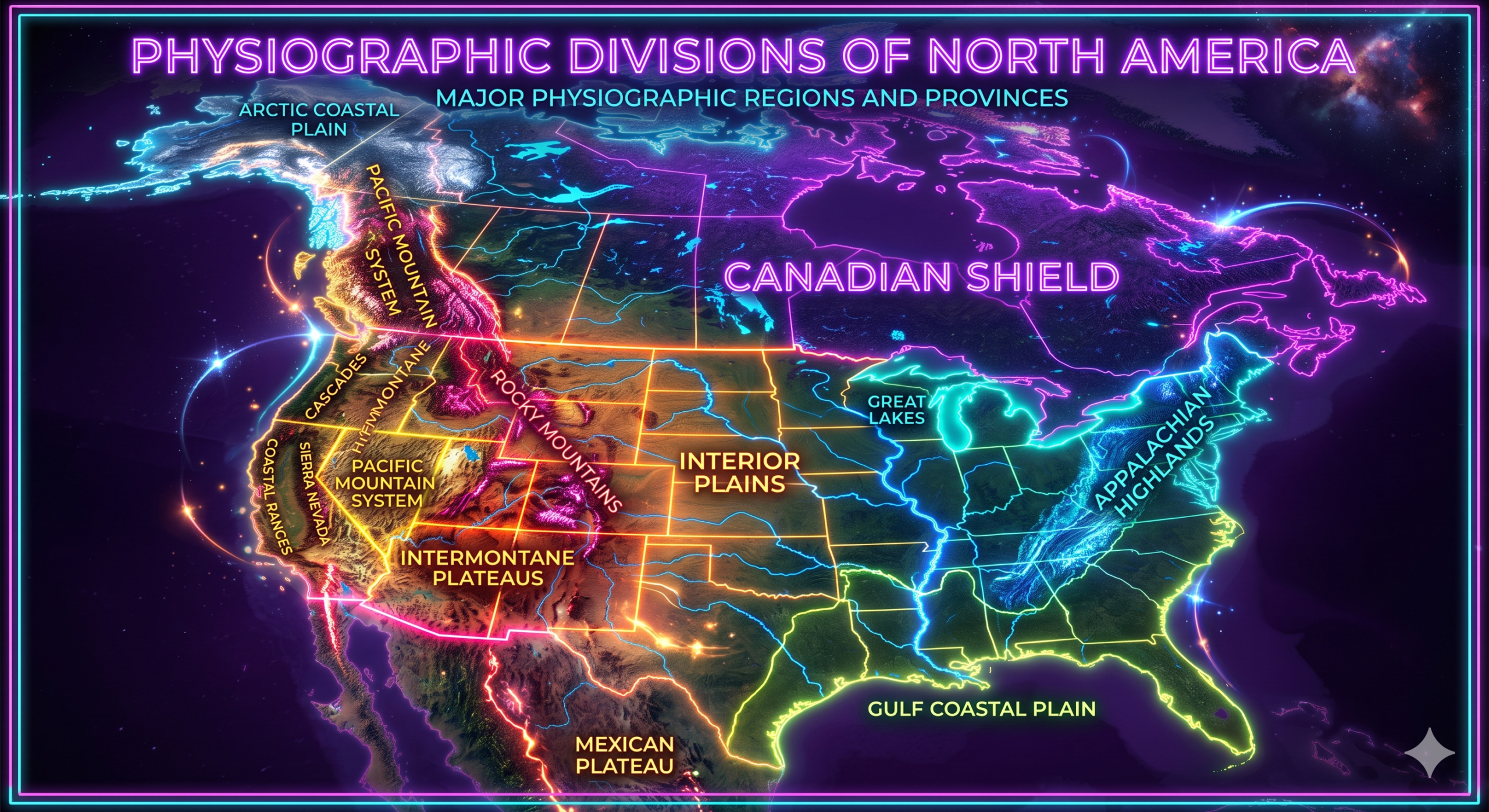
Although different classifications exist, geographers commonly divide North America into the following major physiographic divisions:
- Canadian Shield
- Appalachian Highlands
- Interior Plains
- Great Plains
- Rocky Mountains
- Intermontane Plateaus and Basins
- Pacific Mountain System
- Coastal Plains
- Arctic Lowlands
Each of these regions contributes significantly to the continent’s physical geography and economic development.
1. Canadian Shield
Overview
The Canadian Shield is the oldest and one of the largest physiographic divisions of North America. It forms the geological core of the continent and consists mainly of ancient Precambrian crystalline rocks that are over 2.5 to 4 billion years old.
The Shield occupies nearly half of Canada’s land area and extends into parts of the northern United States.
Location
The Canadian Shield surrounds Hudson Bay and stretches across:
- Quebec
- Ontario
- Manitoba
- Saskatchewan
- Nunavut
- Northwest Territories
- Labrador
- Northern Minnesota
- Wisconsin
- Michigan
- New York
Geological Formation
The Shield formed during the Precambrian Era through repeated volcanic activity, continental collisions, metamorphism, and igneous intrusions. Over billions of years, erosion removed younger rocks, exposing ancient crystalline bedrock at the surface.
During the Ice Ages, massive glaciers scraped the landscape, smoothing hills and carving countless lakes and depressions.
Physical Features
The region is characterized by:
- Ancient granite and gneiss rocks
- Rounded hills
- Thin soils
- Thousands of lakes
- Exposed bedrock
- Poor drainage
- Dense boreal forests
The Canadian Shield contains some of the world’s oldest exposed rocks.
Economic Importance
The Shield is rich in mineral resources, including:
- Gold
- Nickel
- Copper
- Iron ore
- Uranium
- Zinc
- Diamonds
Hydroelectric power generation is also significant due to numerous rivers and lakes.
2. Appalachian Highlands
Overview
The Appalachian Highlands represent one of the oldest mountain systems in North America. Although these mountains were once comparable in height to today’s Himalayas, millions of years of erosion have reduced them to rounded hills and ridges.
Location
The Appalachian Mountains extend approximately 2,400 kilometers from:
- Newfoundland (Canada)
- Through eastern Canada
- New England
- Eastern United States
- Alabama
Geological Formation
These mountains formed during the Paleozoic Era, approximately 480 to 250 million years ago, through continental collisions associated with the formation of the supercontinent Pangaea.
Subsequent weathering and erosion greatly modified their appearance.
Major Landforms
Important subregions include:
- Blue Ridge Mountains
- Great Smoky Mountains
- Allegheny Plateau
- Valley and Ridge Province
- Piedmont Plateau
Characteristics
The region features:
- Rounded mountain peaks
- Deep valleys
- Dense forests
- Coal deposits
- Fertile valleys
- Numerous rivers
Economic Importance
Resources include:
- Coal
- Timber
- Natural gas
- Tourism
- Agriculture
- Hydroelectric power
National parks within the Appalachians attract millions of visitors each year.
3. Interior Plains
Overview
The Interior Plains occupy a vast central region between the Canadian Shield and the Great Plains.
They consist mainly of gently rolling sedimentary lowlands formed by the accumulation of sediments deposited in ancient inland seas.
Location
The Interior Plains extend across:
- Central Canada
- Manitoba
- Saskatchewan
- Alberta
- North Dakota
- South Dakota
- Minnesota
- Iowa
- Missouri
- Illinois
- Indiana
Geological History
Millions of years ago, shallow inland seas covered much of this region.
Marine sediments accumulated over time, eventually forming thick layers of limestone, shale, sandstone, and other sedimentary rocks.
Landforms
The Interior Plains include:
- Rolling plains
- Low plateaus
- River valleys
- Lake basins
- Prairie grasslands
Economic Importance
The Interior Plains support:
- Wheat farming
- Corn cultivation
- Livestock grazing
- Petroleum production
- Natural gas
- Coal mining
The fertile soils make this one of the continent’s most productive agricultural regions.
4. Great Plains
Overview
The Great Plains form a broad belt of elevated grasslands lying east of the Rocky Mountains.
This region gradually rises in elevation from east to west.
Location
The Great Plains extend from:
- Alberta
- Saskatchewan
- Manitoba
Southward through:
- Montana
- Wyoming
- Colorado
- Nebraska
- Kansas
- Oklahoma
- Texas
- New Mexico
Geological Formation
Sediments eroded from the Rocky Mountains accumulated over millions of years, creating thick deposits across the plains.
Wind also deposited fertile loess soils in many areas.
Physical Characteristics
The region contains:
- Flat to gently rolling terrain
- Grasslands
- River valleys
- Badlands
- Sand hills
- Escarpments
Rainfall decreases westward, creating semi-arid conditions.
Economic Importance
The Great Plains are known as the “breadbasket” of North America.
Major activities include:
- Wheat production
- Corn farming
- Cattle ranching
- Oil extraction
- Wind energy
5. Rocky Mountains
Overview
The Rocky Mountains are the largest mountain system in western North America.
They consist of young fold mountains with rugged terrain and high elevations.
Location
The Rockies extend over 4,800 kilometers from:
- British Columbia
- Alberta
Through:
- Montana
- Idaho
- Wyoming
- Colorado
- New Mexico
Geological Formation
The Rockies formed during the Laramide Orogeny, approximately 80–55 million years ago, as tectonic forces compressed and uplifted Earth’s crust.
Physical Features
Important characteristics include:
- Sharp peaks
- Deep valleys
- Glacial lakes
- Alpine meadows
- Snow-covered summits
- High plateaus
Several peaks exceed 4,000 meters in elevation.
Climate
The Rockies influence weather by creating a rain-shadow effect.
Western slopes receive abundant rainfall, while eastern regions are comparatively dry.
Economic Importance
The mountains provide:
- Tourism
- Ski resorts
- Forest resources
- Hydroelectric power
- Mining
- Wildlife habitats
Major national parks preserve these landscapes.
6. Intermontane Plateaus and Basins
Overview
Between the Rocky Mountains and Pacific Mountains lies a region of plateaus, basins, valleys, and deserts collectively called the Intermontane Region.
Major Subregions
These include:
- Columbia Plateau
- Colorado Plateau
- Great Basin
- Basin and Range Province
Colorado Plateau
The Colorado Plateau contains:
- Grand Canyon
- Monument Valley
- Mesa Verde
- Canyonlands
River erosion has created spectacular canyon systems.
Great Basin
This arid region features:
- Internal drainage
- Salt flats
- Desert basins
- Mountain ranges
The Great Salt Lake lies within this region.
Basin and Range Province
Characterized by:
- Parallel mountain ranges
- Fault-block mountains
- Broad valleys
- Desert landscapes
The region formed through crustal stretching.
Economic Importance
Resources include:
- Copper
- Gold
- Uranium
- Tourism
- Solar energy
- Livestock grazing
7. Pacific Mountain System
Overview
The Pacific Mountain System forms the westernmost physiographic division.
It consists of several parallel mountain ranges created by active plate tectonics.
Major Components
These include:
- Sierra Nevada
- Cascade Range
- Coast Mountains
- Alaska Range
Geological Formation
The region continues to experience:
- Earthquakes
- Volcanic eruptions
- Mountain uplift
The Cascades contain numerous active volcanoes.
Physical Features
Characteristics include:
- High mountains
- Deep valleys
- Fjords
- Glaciers
- Volcanic peaks
- Dense forests
Climate
The Pacific Mountains intercept moist Pacific winds, producing heavy rainfall along western slopes.
Economic Importance
Major industries include:
- Forestry
- Fishing
- Tourism
- Hydroelectric power
- Fruit farming
- Technology hubs in nearby valleys
8. Coastal Plains
Overview
The Coastal Plains form broad, low-lying regions bordering the Atlantic Ocean and Gulf of Mexico.
Location
They extend from:
- New Jersey
- Delaware
- Maryland
- Virginia
Southward through:
- Carolinas
- Georgia
- Florida
Then westward along:
- Gulf Coast
- Alabama
- Mississippi
- Louisiana
- Texas
Geological Formation
The plains developed through sediment deposition by rivers and marine processes over millions of years.
Landforms
Features include:
- Beaches
- Barrier islands
- Wetlands
- Estuaries
- River deltas
- Marshes
Economic Importance
Activities include:
- Agriculture
- Fishing
- Oil production
- Tourism
- Shipping
- Port development
The Mississippi Delta is one of the world’s largest depositional features.
9. Arctic Lowlands
Overview
The Arctic Lowlands occupy the northernmost regions of Canada.
They consist of flat, poorly drained terrain underlain by permafrost.
Characteristics
Features include:
- Tundra vegetation
- Permafrost
- Marshes
- Lakes
- Low relief
- Cold climate
Climate
The region experiences:
- Long winters
- Short summers
- Low precipitation
- Strong winds
Economic Importance
Despite harsh conditions, the Arctic contains:
- Petroleum
- Natural gas
- Minerals
- Fisheries
It also supports unique wildlife such as polar bears, musk oxen, and migratory birds.
Relationship Between Physiographic Divisions
Although each physiographic division has distinct characteristics, they are interconnected through geological and environmental processes.
For example:
- Rivers originating in the Rocky Mountains transport sediments to the Great Plains and Coastal Plains.
- Glaciers shaped both the Canadian Shield and northern Interior Plains.
- Mountain ranges influence regional climate and rainfall patterns.
- Coastal regions receive sediments from inland river systems.
Together, these interactions create the dynamic physical landscape of North America.
Importance of Studying Physiographic Divisions
Understanding North America’s physiographic divisions is important because they:
- Explain the continent’s geological history.
- Help identify natural resources such as minerals, oil, and groundwater.
- Support agricultural planning by identifying fertile regions.
- Aid in natural hazard assessment, including earthquakes, floods, landslides, and volcanic activity.
- Assist in environmental conservation and land-use planning.
- Improve understanding of climate, ecosystems, and biodiversity.
- Guide infrastructure development and sustainable resource management.
Knowledge of physiographic regions also helps students appreciate how geology influences human settlement, economic activities, transportation, and environmental management.
Conclusion
North America’s remarkable physical diversity is the result of billions of years of geological evolution. The continent’s major physiographic divisions—the Canadian Shield, Appalachian Highlands, Interior Plains, Great Plains, Rocky Mountains, Intermontane Plateaus and Basins, Pacific Mountain System, Coastal Plains, and Arctic Lowlands—each represent unique combinations of geological structure, topography, climate, and natural resources. Ancient crystalline rocks, eroded mountain ranges, fertile plains, towering young mountains, desert plateaus, volcanic landscapes, low-lying coastal regions, and frozen Arctic terrains together create one of the most varied physical landscapes on Earth.
Studying these physiographic divisions provides valuable insight into the processes that have shaped the continent and continues to support scientific research, education, environmental conservation, resource management, disaster mitigation, and sustainable development. A clear understanding of these natural regions enables students and researchers to better appreciate the relationship between Earth’s geological history and the modern landscapes that influence both natural ecosystems and human societies.