Introduction
Glaciation has been one of the most powerful natural forces responsible for shaping the physical landscape of North America. Over the past 2.6 million years, during the Quaternary Period, repeated advances and retreats of massive glaciers transformed large parts of the continent. These glaciers carved mountains, widened valleys, created thousands of lakes, deposited fertile soils, altered river systems, and influenced the development of ecosystems and human settlements.
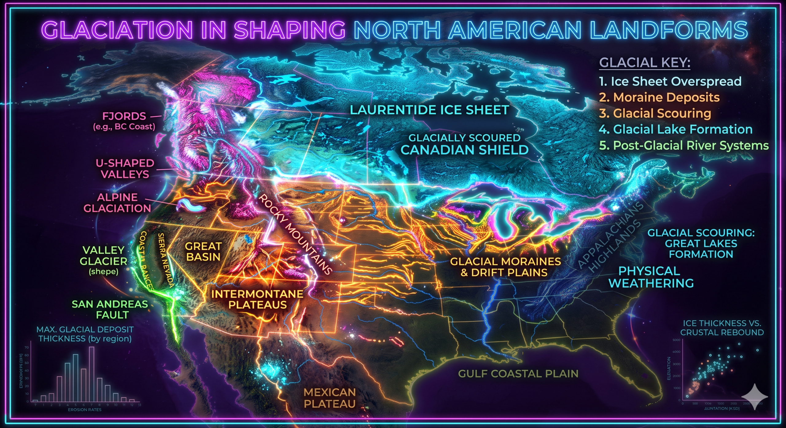
Today, many of North America’s most recognizable landforms—including the Great Lakes, Canadian Shield, Finger Lakes, Niagara Escarpment, U-shaped valleys of the Rocky Mountains, and numerous fjords along the Pacific coast—owe their present appearance to glacial activity. Even though the continental ice sheets disappeared thousands of years ago, their impact remains clearly visible across Canada, the northern United States, and parts of Alaska.
From a geomorphological perspective, glaciers act as powerful agents of both erosion and deposition. As glaciers move slowly across the Earth’s surface, they erode rock through abrasion and plucking, transport enormous quantities of sediment, and deposit this material in distinctive landforms when the ice melts. Understanding glaciation is therefore essential for interpreting the geological history, physical geography, hydrology, soils, ecosystems, and natural resources of North America.
What is Glaciation?
Glaciation refers to the formation, movement, and melting of glaciers and ice sheets that modify Earth’s surface through erosion, transportation, and deposition of rock materials.
A glacier forms when snowfall accumulates over many years, becomes compressed into dense ice, and begins to flow slowly under its own weight.
Unlike rivers, glaciers can transport extremely large rocks, reshape entire mountain ranges, and dramatically alter continental landscapes.
The Ice Ages of North America
Most glacial landforms visible today were created during the Pleistocene Epoch, which lasted from approximately 2.58 million years ago to about 11,700 years ago.
During this period, Earth experienced several cold climatic phases known as Ice Ages. Large portions of North America were covered by continental ice sheets that reached thicknesses of more than 3 kilometers in some places.
The principal ice sheets were:
- Laurentide Ice Sheet
- Cordilleran Ice Sheet
- Innuitian Ice Sheet
Together, they covered nearly all of Canada and extended into the northern United States.
Major Ice Sheets
1. Laurentide Ice Sheet
The Laurentide Ice Sheet was the largest glacier in North America.
It covered:
- Most of Canada
- Great Lakes region
- New England
- Northern Great Plains
- Upper Midwest
Its movement profoundly shaped eastern and central North America.
2. Cordilleran Ice Sheet
This ice sheet occupied western North America.
It covered:
- British Columbia
- Yukon
- Alaska
- Western mountain ranges
It interacted with mountain glaciers to produce spectacular alpine landforms.
3. Innuitian Ice Sheet
Located in the Canadian Arctic Archipelago, this ice sheet shaped the northernmost islands of Canada and contributed to Arctic landform development.
Types of Glaciers
North America experienced two major glacier types.
Continental Glaciers
These were enormous ice sheets covering millions of square kilometers.
Examples include the Laurentide and Cordilleran Ice Sheets.
Alpine Glaciers
Mountain glaciers occupied valleys in regions such as:
- Rocky Mountains
- Sierra Nevada
- Cascade Range
- Alaska Range
They produced distinctive mountainous landforms.
Processes of Glacial Erosion
Glaciers reshape landscapes mainly through two erosional processes.
1. Abrasion
As glaciers move, rock fragments frozen into their base scrape against underlying bedrock.
This process:
- Smooths rock surfaces
- Produces grooves and scratches
- Widens valleys
- Polishes bedrock
Abrasion acts like giant sandpaper moving across the Earth’s surface.
2. Plucking
When glacier ice freezes onto fractured bedrock, it pulls away large rock blocks as it moves.
Plucking creates:
- Steep cliffs
- Jagged mountain peaks
- Deep valleys
- Irregular rock surfaces
Abrasion and plucking often work together to reshape landscapes.
Transportation of Glacial Material
Glaciers transport enormous amounts of sediment known as glacial drift.
Transported materials include:
- Clay
- Sand
- Gravel
- Pebbles
- Boulders
- Large rock blocks
This material may be carried:
- On the glacier surface
- Within the ice
- At the glacier base
Some transported boulders travel hundreds of kilometers from their original locations.
Glacial Deposition
When glaciers melt, they deposit sediments that form distinctive landforms.
Deposited material is known as:
- Till (unsorted sediment)
- Outwash (sorted sediments deposited by meltwater)
These deposits have shaped much of North America’s modern landscape.
Major Glacial Landforms in North America
Glaciation produced numerous erosional and depositional landforms.
1. U-Shaped Valleys
Mountain glaciers transformed narrow river valleys into broad U-shaped valleys.
Characteristics include:
- Flat valley floors
- Steep valley walls
- Wide cross-sections
Excellent examples occur in:
- Rocky Mountains
- Alaska
- Sierra Nevada
2. Cirques
Cirques are bowl-shaped depressions formed near mountain summits where glaciers originate.
Characteristics:
- Steep back walls
- Curved basins
- Often contain small lakes called tarns
Many cirques are found throughout the Rocky Mountains.
3. Arêtes
Arêtes are narrow, knife-edged ridges formed between adjacent cirques.
They are among the most striking alpine landforms.
4. Horns
When several cirques erode around a mountain peak, a sharp pyramidal summit known as a horn develops.
Examples occur in the Canadian Rockies.
5. Hanging Valleys
Smaller tributary glaciers eroded less deeply than larger glaciers.
After ice retreat, these valleys remained elevated above the main valley floor.
Waterfalls commonly occur where hanging valleys meet larger valleys.
6. Fjords
Along the Pacific coast of Alaska and British Columbia, glaciers carved deep valleys that were later flooded by the sea.
These drowned glacial valleys are called fjords.
Characteristics include:
- Deep water
- Steep cliffs
- Narrow inlets
7. Moraines
Moraines are ridges of unsorted glacial debris deposited by glaciers.
Types include:
- Terminal moraines
- Lateral moraines
- Medial moraines
- Ground moraines
These features indicate former glacier positions.
8. Drumlins
Drumlins are streamlined hills composed mainly of glacial till.
Characteristics:
- Oval shape
- Steep upstream side
- Gentle downstream slope
Large drumlin fields occur in:
- New York
- Wisconsin
- Ontario
9. Eskers
Eskers are long, winding ridges formed by sediments deposited within meltwater tunnels beneath glaciers.
They resemble winding natural embankments.
10. Kettle Lakes
Large ice blocks left behind after glacier retreat eventually melted, leaving depressions that filled with water.
These became kettle lakes.
Thousands occur across Canada and the northern United States.
11. Outwash Plains
Meltwater streams deposited well-sorted sand and gravel beyond glacier margins.
These broad plains are called outwash plains.
12. Erratic Boulders
Glaciers transported massive rocks far from their original locations.
These isolated rocks are known as glacial erratics.
They provide important evidence of former ice movement.
Formation of the Great Lakes
One of the greatest geomorphological achievements of glaciation is the formation of the Great Lakes.
During the Ice Age:
- Glaciers deepened existing river valleys.
- Ice eroded bedrock basins.
- Retreating glaciers left depressions.
- Meltwater filled these basins.
The resulting lakes are:
- Lake Superior
- Lake Michigan
- Lake Huron
- Lake Erie
- Lake Ontario
Together they form the largest freshwater lake system in the world by surface area.
Influence on the Canadian Shield
The Canadian Shield was extensively modified by glaciation.
Glaciers:
- Removed weathered rock
- Exposed ancient bedrock
- Created thousands of lakes
- Smoothed hills
- Produced thin soils
The Shield’s rugged landscape is largely a product of repeated glaciation.
Modification of River Systems
Glaciation dramatically altered North America’s drainage patterns.
Examples include:
- Diversion of river courses
- Formation of new lakes
- Development of waterfalls
- Creation of wetlands
- Expansion of floodplains
Niagara Falls formed after glacial retreat altered drainage between Lakes Erie and Ontario.
Soil Formation
Glacial deposits produced fertile soils across much of North America.
Examples include:
- Prairie soils
- Agricultural regions around the Great Lakes
- Northern United States farmlands
These soils support extensive agriculture.
Influence on Climate
Although glaciers retreated thousands of years ago, they continue to influence regional climates through:
- Large freshwater lakes
- Snow accumulation
- Mountain glaciers
- Arctic ice masses
The Great Lakes moderate temperatures and affect regional precipitation patterns.
Influence on Biodiversity
Glacial retreat created new habitats.
Plants and animals gradually recolonized newly exposed land.
This process contributed to the diversity of:
- Forests
- Wetlands
- Grasslands
- Freshwater ecosystems
Economic Importance of Glacial Landforms
Glacial landscapes support numerous human activities.
Agriculture
Glacial soils are highly productive.
Major crops include:
- Wheat
- Corn
- Soybeans
- Barley
Freshwater Resources
The Great Lakes supply water for:
- Drinking
- Industry
- Agriculture
- Hydroelectric power
- Navigation
Mining
Glacial erosion exposed valuable mineral deposits.
Important resources include:
- Iron ore
- Nickel
- Copper
- Gold
Tourism
Glacial landscapes attract millions of visitors.
Popular destinations include:
- Banff National Park
- Jasper National Park
- Glacier National Park
- Great Lakes region
- Alaska fjords
Modern Glaciers in North America
Although continental glaciers disappeared long ago, active glaciers still exist in:
- Alaska
- Canadian Rockies
- Coast Mountains
- Yukon
- Arctic Islands
These glaciers continue to reshape mountain landscapes.
Climate Change and Glacial Retreat
Modern glaciers are retreating due to global warming.
Scientists observe:
- Shrinking glaciers
- Reduced snowpack
- Rising sea levels
- Altered river flows
- Increased glacial lake formation
Studying these changes helps scientists understand future environmental challenges.
Geomorphological Significance of Glaciation
Glaciation is one of the most important geomorphological processes because it:
- Reshaped nearly half of North America.
- Produced distinctive erosional and depositional landforms.
- Created thousands of lakes.
- Modified drainage systems.
- Formed fertile agricultural soils.
- Influenced ecosystems and biodiversity.
- Exposed valuable mineral resources.
- Preserved evidence of Earth’s climatic history.
- Continues to influence mountain landscapes and hydrological systems.
Without glaciation, North America’s physical geography would be dramatically different.
Conclusion
Glaciation has played a fundamental role in shaping the landforms of North America. During the Pleistocene Ice Age, vast continental ice sheets and alpine glaciers transformed the continent through erosion, transportation, and deposition. These processes produced iconic features such as the Great Lakes, U-shaped valleys, cirques, moraines, drumlins, eskers, fjords, kettle lakes, and outwash plains. Glacial activity also reshaped river systems, exposed ancient bedrock, created fertile soils, and influenced climate, biodiversity, and water resources.
The legacy of glaciation extends beyond physical geography. It supports agriculture, freshwater supplies, tourism, mineral exploration, and environmental research. Moreover, modern glaciers continue to provide valuable evidence of climate change and ongoing landscape evolution. For students of geography and Earth science, the study of glaciation offers a deeper understanding of how powerful natural processes have shaped North America over millions of years and continue to influence its environment today.