Introduction
The United States is one of the world’s most geographically diverse countries, covering a vast area from the Atlantic Ocean in the east to the Pacific Ocean in the west and from the Arctic-influenced regions of Alaska to the tropical islands of Hawaii. Because of its immense size and varied landscapes, the United States experiences a wide range of climatic conditions, including humid subtropical climates, arid deserts, Mediterranean climates, alpine climates, tundra environments, and tropical regions.
Climate refers to the long-term average pattern of weather conditions in a particular area. It includes factors such as temperature, precipitation, humidity, wind, and seasonal changes. The climate of the United States is influenced by numerous natural factors that interact with one another to create distinct regional climates.
Understanding these climatic influences is essential for studying geography, environmental science, agriculture, water resources, ecosystems, and human activities. This article examines the major factors that influence the climate of the United States and explains how these factors shape weather patterns across the country.
Latitude
One of the most fundamental factors affecting climate is latitude.
Latitude refers to a location’s distance north or south of the Equator. Because the Earth is curved, different latitudes receive varying amounts of solar energy.
Influence on Temperature
Regions closer to the Equator receive more direct sunlight and generally experience warmer temperatures. Areas farther from the Equator receive less direct sunlight and are therefore cooler.
In the United States:
- Southern states generally experience warmer climates.
- Northern states experience colder climates.
- Alaska experiences some of the coldest temperatures in North America.
Seasonal Variation
Latitude also affects the length of daylight throughout the year. Northern states experience larger seasonal variations than southern states, resulting in more pronounced summer and winter seasons.
Thus, latitude is one of the primary reasons for temperature differences across the country.
Distance from Oceans and Large Water Bodies
The United States is bordered by the Atlantic Ocean, Pacific Ocean, Gulf of Mexico, and several large lakes.
Maritime Influence
Water heats and cools more slowly than land. As a result, coastal areas tend to experience milder temperatures throughout the year.
Coastal Climates
Areas near oceans often have:
- Smaller temperature ranges
- Higher humidity
- More moderate winters
- Cooler summers
For example, coastal California experiences relatively mild temperatures compared with inland desert regions.
Continental Climate
Interior regions far from oceans experience greater temperature extremes because land surfaces heat and cool rapidly.
This is why the central United States often experiences very hot summers and very cold winters.
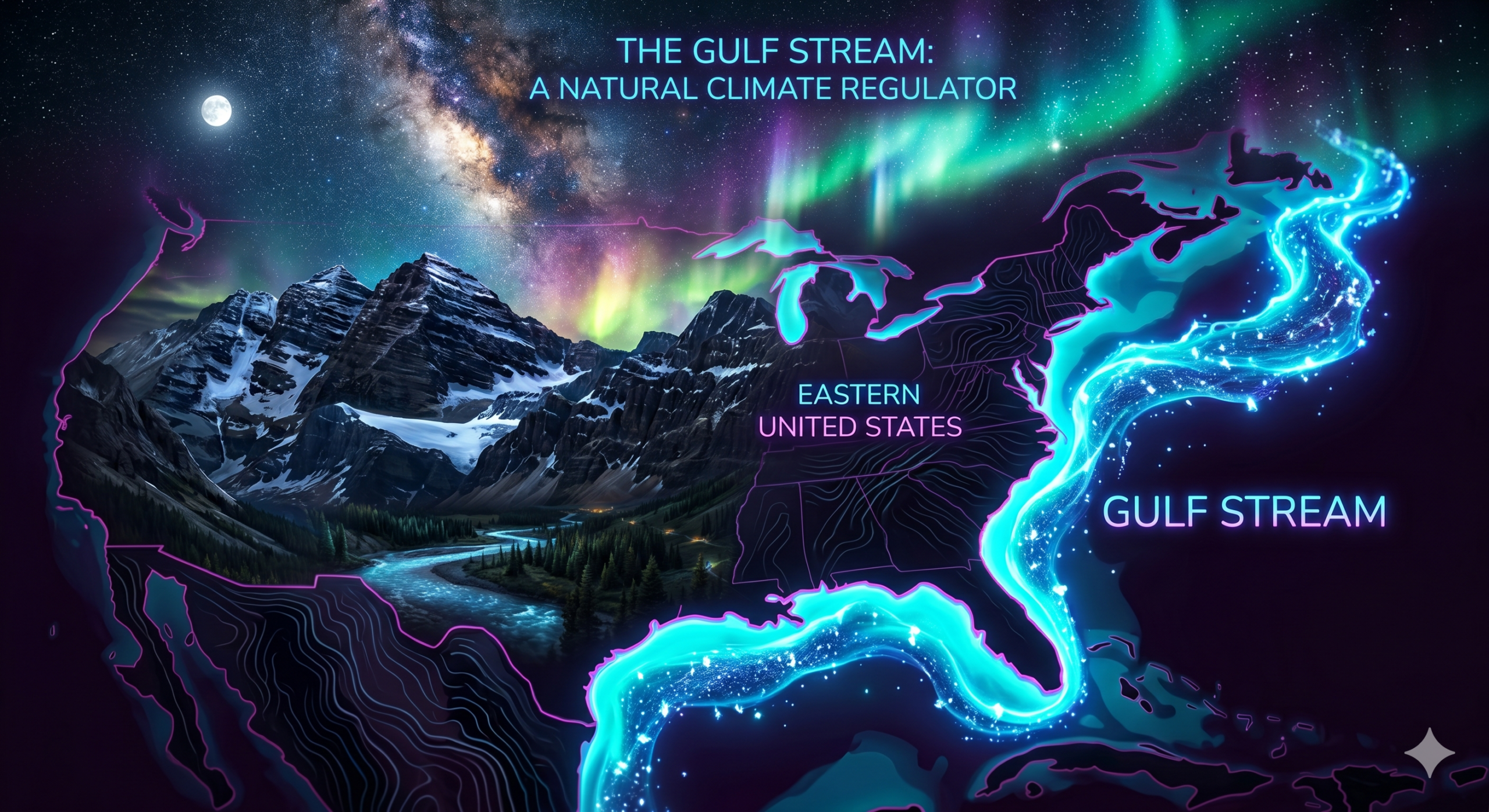
Ocean Currents
Ocean currents play a major role in regulating climate along coastal regions.
Gulf Stream
The Gulf Stream is a warm Atlantic Ocean current that flows along the eastern coast of the United States.
Its effects include:
- Warmer coastal temperatures
- Increased humidity
- Greater precipitation
- Enhanced storm development
The Gulf Stream contributes significantly to the humid climate of the southeastern United States.
California Current
The California Current is a cold ocean current flowing southward along the Pacific Coast.
Its effects include:
- Cooler coastal temperatures
- Reduced evaporation
- Lower humidity
- Limited rainfall
This current contributes to the relatively dry climate of California’s coastal regions.
Prevailing Winds
Winds transport heat and moisture across large distances.
Global Wind Systems
The United States is primarily influenced by:
- Westerlies
- Trade winds
- Polar easterlies
These wind systems help distribute temperature and moisture throughout the country.
Moisture Transport
Winds carry moisture from oceans and the Gulf of Mexico into the interior.
When moist air encounters favorable conditions, clouds and precipitation form.
The direction and strength of prevailing winds strongly influence regional weather patterns.
Air Masses
An air mass is a large body of air with relatively uniform temperature and humidity characteristics.
Several major air masses affect the United States.
Maritime Tropical (mT)
Origin:
- Gulf of Mexico
- Caribbean Sea
- Atlantic Ocean
Characteristics:
- Warm
- Humid
Effects:
- Rainfall
- Thunderstorms
- Humid summers
Continental Tropical (cT)
Origin:
- Northern Mexico
- Southwestern deserts
Characteristics:
- Hot
- Dry
Effects:
- Heat waves
- Dry weather
Continental Polar (cP)
Origin:
- Canada
Characteristics:
- Cold
- Dry
Effects:
- Winter cold outbreaks
Maritime Polar (mP)
Origin:
- North Pacific Ocean
Characteristics:
- Cool
- Moist
Effects:
- Cloudy weather
- Rainfall
The interaction of these air masses contributes significantly to weather and climate across the United States.
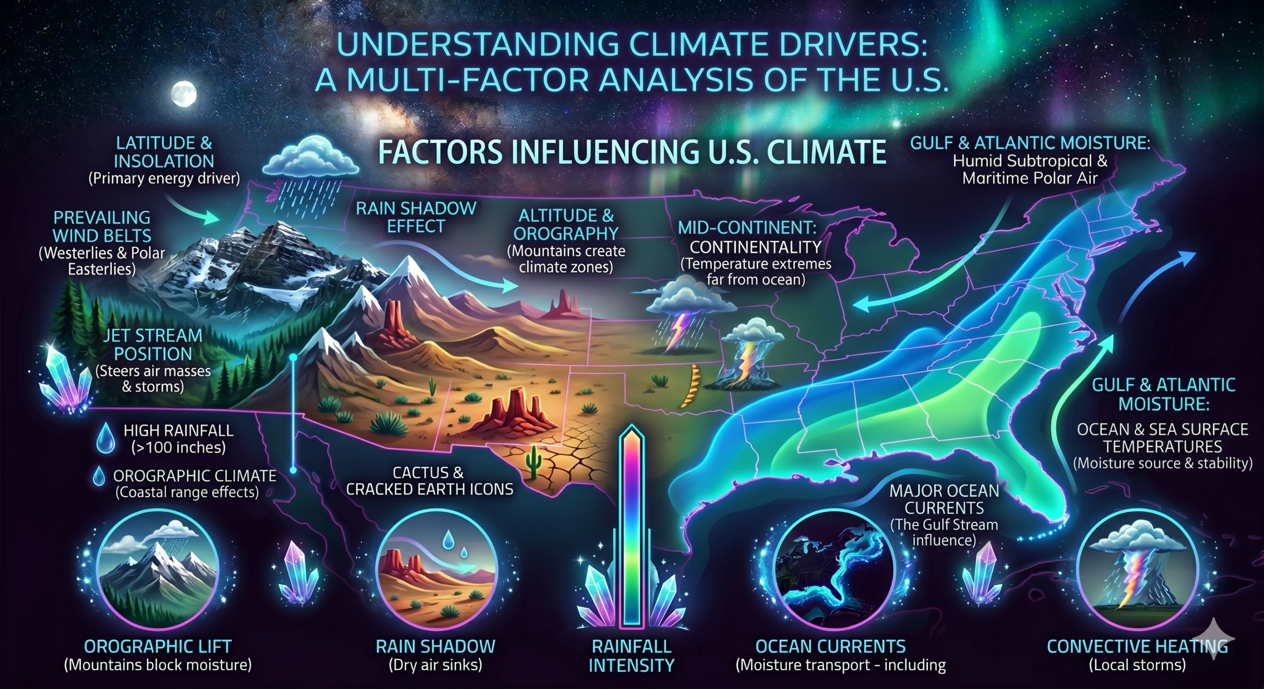
Mountain Ranges
Mountains strongly influence climate through their effects on temperature and precipitation.
Rocky Mountains
The Rocky Mountains extend from Canada into the southwestern United States.
Their climatic effects include:
- Blocking air masses
- Influencing storm tracks
- Creating rain shadow regions
Sierra Nevada and Cascade Ranges
These mountain systems affect the western United States.
Moist Pacific air rises over the mountains, cools, and produces precipitation on western slopes.
As air descends on the eastern side, it becomes warmer and drier.
This process creates arid conditions in parts of Nevada, Utah, and Arizona.
Elevation Effects
Temperature decreases with altitude.
Mountain regions often experience:
- Cooler temperatures
- Greater snowfall
- Shorter growing seasons
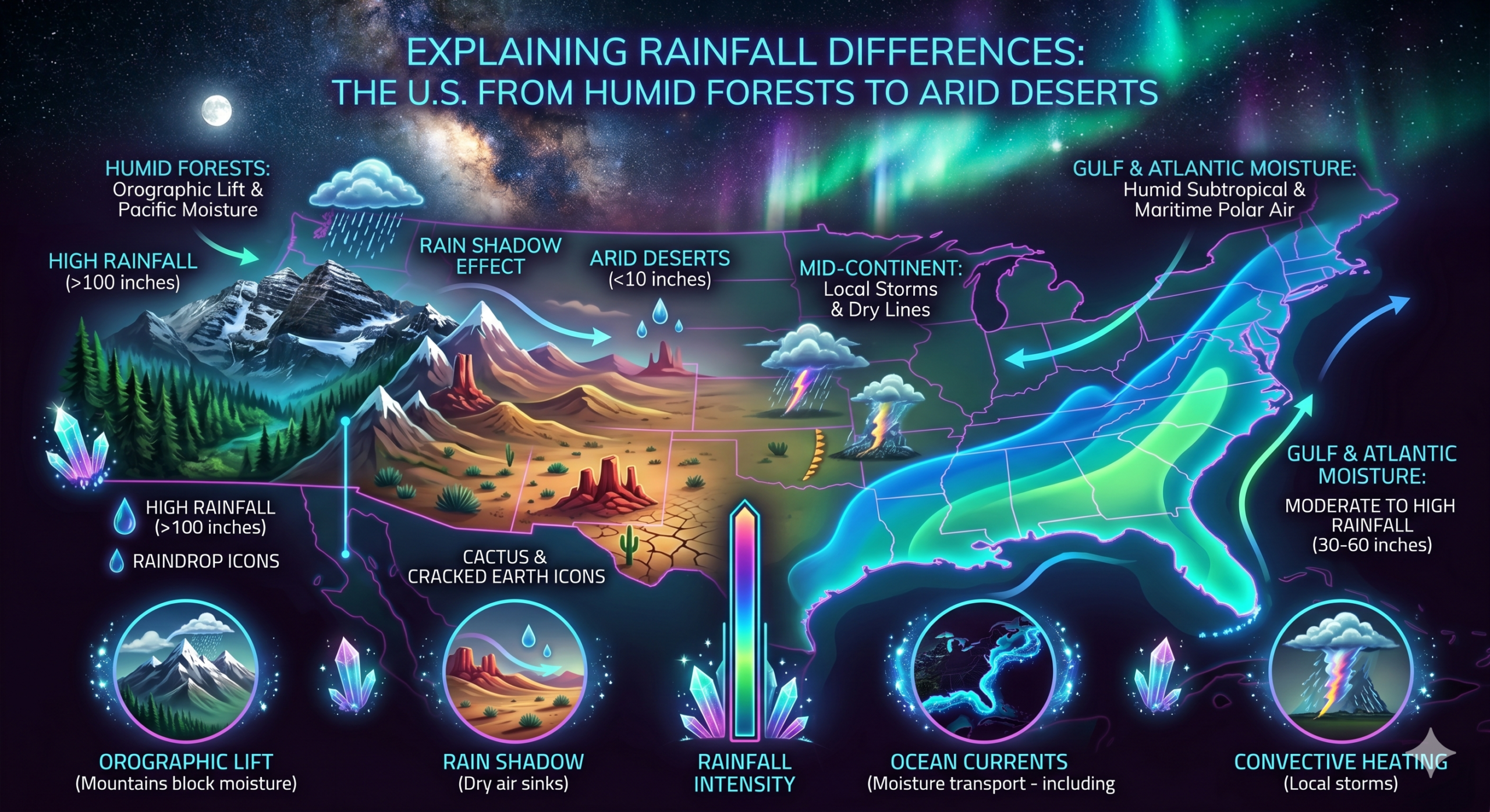
The Rain Shadow Effect
The rain shadow effect occurs when mountains block moisture-bearing winds.
Process
- Moist air rises over mountains.
- Air cools and releases precipitation.
- Air descends on the opposite side.
- Descending air becomes warmer and drier.
Impact in the United States
The western mountain ranges create extensive dry regions in the Southwest.
Many desert areas exist because of this effect.
Examples include:
- Mojave Desert
- Great Basin Desert
- Sonoran Desert
The rain shadow effect is a major factor influencing precipitation patterns.
Elevation
Elevation directly affects climate.
Temperature Changes
On average, temperature decreases by approximately 6.5°C for every 1,000 meters of elevation gain.
High-Altitude Climates
Mountain areas often experience:
- Cool summers
- Cold winters
- Heavy snowfall
Microclimates
Different elevations within the same region can create diverse local climates.
This contributes to ecological diversity across the United States.
The Gulf of Mexico
The Gulf of Mexico is one of the country’s most important moisture sources.
Humidity
Warm Gulf waters produce substantial evaporation.
The resulting moisture contributes to:
- Humid conditions
- Cloud formation
- Frequent rainfall
Severe Weather
The Gulf supplies energy and moisture for:
- Thunderstorms
- Tropical storms
- Hurricanes
Many southeastern states receive abundant rainfall because of their proximity to the Gulf.
Tropical Cyclones and Hurricanes
Hurricanes significantly influence climate in coastal regions.
Formation
These storms develop over warm ocean waters.
Effects
Hurricanes bring:
- Heavy rainfall
- Strong winds
- Flooding
- Storm surges
States along the Gulf Coast and Atlantic Coast are particularly vulnerable.
Although hurricanes are episodic events, they contribute substantially to annual rainfall totals in some regions.
Jet Streams
Jet streams are fast-moving air currents located high in the atmosphere.
Polar Jet Stream
The polar jet stream strongly influences weather systems across the United States.
Climatic Effects
Jet streams:
- Guide storm tracks
- Separate warm and cold air masses
- Influence seasonal weather patterns
Changes in jet stream position can dramatically affect regional climates.
The Great Lakes
The Great Lakes influence the climate of surrounding regions.
Temperature Moderation
Large bodies of water reduce temperature extremes.
Lake-Effect Snow
During winter, cold air moving over relatively warm lake waters absorbs moisture.
This moisture later falls as heavy snow downwind of the lakes.
States frequently affected include:
- Michigan
- New York
- Ohio
- Pennsylvania
Lake-effect snow is one of the most distinctive climatic phenomena in the northeastern United States.
Vegetation and Land Cover
Natural vegetation influences climate through interactions with the atmosphere.
Forests
Forests:
- Absorb solar radiation
- Release moisture through transpiration
- Moderate temperatures
Grasslands
Grasslands affect wind movement and surface temperatures.
Deserts
Deserts have:
- Minimal vegetation
- Low humidity
- Large temperature fluctuations
Different land-cover types influence local climate conditions.
Solar Radiation
The Sun is the ultimate source of energy driving Earth’s climate system.
Uneven Heating
Different regions receive different amounts of solar energy.
Factors affecting solar radiation include:
- Latitude
- Season
- Cloud cover
- Surface characteristics
Variations in solar heating help create regional climate differences.
Seasonal Changes
The Earth’s tilted axis causes seasonal variations.
Summer
Higher sun angles produce:
- Longer days
- Warmer temperatures
Winter
Lower sun angles produce:
- Shorter days
- Cooler temperatures
Seasonal shifts affect temperature, precipitation, and weather patterns throughout the United States.
Climate Change
Modern climate change is increasingly influencing the climate of the United States.
Rising Temperatures
Average temperatures have increased in many regions.
Changes in Precipitation
Some areas are experiencing:
- More intense rainfall
- Increased flooding
- Greater drought frequency
Extreme Weather
Climate change may contribute to:
- Stronger heat waves
- Wildfires
- Severe storms
- Coastal flooding
Understanding climate change has become an essential component of climatology and environmental studies.
Human Activities
Human actions can also influence local and regional climate conditions.
Urbanization
Cities often experience the Urban Heat Island Effect.
Characteristics include:
- Higher temperatures
- Reduced vegetation
- Increased heat absorption
Land Use Changes
Agriculture, deforestation, and development can alter local climate conditions.
Air Pollution
Certain pollutants affect atmospheric processes and cloud formation.
Although natural factors remain dominant, human activities increasingly influence climate patterns.
Interactions Among Climatic Factors
No single factor determines the climate of the United States.
Instead, climate results from the interaction of:
- Latitude
- Oceans
- Ocean currents
- Winds
- Air masses
- Mountains
- Elevation
- Vegetation
- Seasonal changes
- Human influences
These factors work together to create the diverse climates found across the country.
Conclusion
The climate of the United States is shaped by a complex combination of physical and atmospheric factors. Latitude determines the amount of solar energy received, while oceans and large water bodies moderate temperatures and provide moisture. Ocean currents such as the Gulf Stream and California Current influence coastal climates, while prevailing winds and air masses transport heat and humidity across the continent. Mountain ranges create rain shadows and influence precipitation patterns, and elevation affects temperature and snowfall.
Additional influences include the Gulf of Mexico, hurricanes, jet streams, the Great Lakes, vegetation, seasonal changes, climate change, and human activities. Together, these factors create the remarkable climatic diversity that characterizes the United States. Understanding these influences provides valuable insight into weather patterns, ecosystems, agriculture, water resources, and environmental management, making climatology an essential field of study for understanding both natural and human environments.